Aeris, LLC
  • 720-370-9012
  • email us
Aeris, LLC
  • HOME
  • ABOUT AERIS
    • Aeris Team
    • Publications
    • Contact Us
  • SOLUTIONS
    • Modeling, Simulation & Analysis
    • Subject Matter Expertise
    • Software Development
  • PROJECTS
  • NEWS
  • CAREERS

MODELING, SIMULATION & ANALYSIS

OUR APPROACH
Aeris specializes in the mathematical/numerical modeling of environmental phenomena and subsequent analysis of the impacts to downstream environmentally sensitive systems. Our approach for providing this service first begins by working closely with our customers to clearly identify their unique problems and fundamental questions. Next, a customized modeling and simulation methodology is designed to generate the required raw data and information, at the required spatiotemporal fidelities, which will be subsequently used to inform further analytical studies. Generation of these raw simulation products are either delivered directly to the customer for their own internal use/analysis or utilized by Aeris scientists and engineers to perform a tailored analysis to meet the customer’s specific needs.

Core Capabilites

Aeris utilizes state of the art government/commercial off the shelf (GOTS/COTS) environmental modeling tools and datasets combined with the latest published analytical methodologies to provide tailored modeling and simulation solutions. Specific examples of these solutions and associated tools/methods are detailed below:

Numerical Weather Prediction (NWP)
Aeris can develop and deliver numerically generated weather forecast products for specific regions of interest and tailored to the needs of the end application. For this purpose, Aeris utilizes both research grade and operationally available NWP systems, including the Weather Research and Forecast (WRF) model, developed by the National Center for Atmospheric Research (NCAR), and GPU Resident Atmospheric Simulation Program (GRASP), developed by Whiffle LTD, optimized for execution on both traditional CPU based and GPU massively parallel hardware architectures. The final forecast solution/system can either be hosted in house, by Aeris staff, or operationally implemented at the client’s site on available customer resources.

Atmospheric Contaminant Transport and Dispersion Prediction
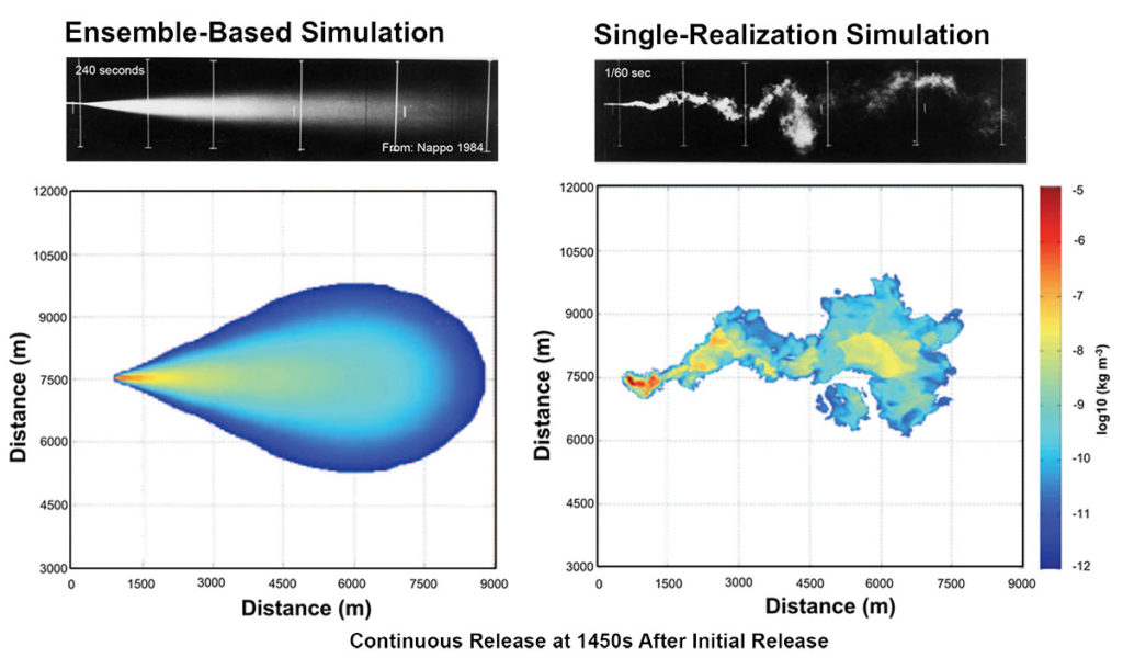
Aeris staff have extensive experience utilizing a variety of atmospheric dispersion modeling tools and methods to predict and analyze the downstream concentrations, exposures, and effects from Chemical, Biological, Radiological, and Nuclear (CBRN) atmospheric release events. These tools and methods include the Second order Closure Integrated PUFF (SCIPUFF) model, contained within the Department Of Defense (DoD) Hazard Prediction and Assessment Capability (HPAC) and Joint Effects Model (JEM) CBRN Decision Aids; the Environmental Protection Agency (EPA) recommended regulatory atmospheric dispersion modeling system, CALPUFF; and the Quick Urban & Industrial Complex (QUIC) dispersion modeling system developed by Los Alamos National Laboratory. Examples of end applications, where Aeris has utilized these modeling tools, include CBRN emergency response guidance, CBRN source term estimation, and CBRN field test support.

Historical Climate Analysis
Climate analysis involves the statistical analysis of past weather conditions to identify trends and patterns of interest for specific locations or regions. For these analyses, we utilize pre-existing climate data resources provided by the National Centers for Environmental Information (NCEI), National Center for Environmental Prediction (NCEP), and NCAR, either in isolation or to initialize climate downscaling simulations, using the NWP models, discussed earlier, to generate even higher resolution climate reanalysis products. In addition to generating standard climate statistics from these analyses, Aeris has also utilized a variety of Artificial Intelligence (AI) based data mining methodologies, such as the Self-organizing Map (SOM), for extracting additional signals and identifying recurring climate patterns of interest. The raw climate analysis products, from this process, can also be utilized to initialize secondary environmental model simulations, such as contaminant transport simulations, to generate a corresponding climatology of those secondary processes and associated effects. Aeris staff have utilized this process to support a number of applications such as strategic CBRN related risk assessments, air quality regulatory compliance studies, and CBRN sensor placement optimization.

Synthetic Environment Generation
Aeris can generate hyper realistic synthetic representations of environmental phenomena, such as clouds, obscurants, natural radiation, contaminants, and turbulence, for idealized conditions and environments (e.g. urban, desert, etc), as specifically requested by the customer. For this, Aeris has traditionally utilized the Large Eddy Simulation (LES) capabilities inherent in the WRF modeling system and, more recently, the Urban LES capabilities provided by the GRASP system. Once generated, these synthetic environments can be utilized to support a number of end applications, including CBRN Field Test Design/Optimization, Virtual Testing and Evaluation (VT&E) of sensor designs, and Virtual Combat Training.

Historical Environmental Reconstruction
Aeris can generate 4-dimensional reconstructions of atmospheric conditions and specific weather phenomena to support retrospective analyses of a specific historical event. These reconstructions can be utilized by themselves or can be coupled to secondary environmental model systems (e.g. contaminant transport models) to provide corresponding reconstructions of those secondary environmental events. The final reconstructed event can then be utilized to support a variety of end applications including aviation incident investigations, air quality regulatory compliance confirmation, consequence management of atmospheric releases of chemical, biological, and radiological materials, confirmation of compliance with the comprehensive nuclear test ban treaty (CTBT), and finally basic/applied scientific research.

Numerical Model Validation
Before utilizing any numerical modeling tool or method, it is of critical importance to determine the level of accuracy of the model generated results. Many of the modeling tools, currently being utilized by the Aeris scientific team, have been and continue to be validated by the general scientific community and the associated validation results published in the peer review literature. Aeris staff scientists and engineers have actively participated in many of these past validation exercises, have co-authored a variety of associated validation studies, and continue to support validation of new and emerging numerical modeling systems.

Related Projects
  • Operational Assimilation of LIDAR Derived Backscatter and Wind Data into an Atmospheric Transport and Dispersion Model
  • Joint Effects Model (JEM) Increment 2 Development
  • Urban Coupled Indoor-Outdoor Modeling and Synthetic Environments
  • Environmental Management System (EMS) Decision Aid Product (EDAPT)

Numerical Weather Prediction

Atmospheric Contaminant Transport and Dispersion Prediction

Synthetic Environment Generation

Historical Climate Analysis

Historical Environmental Reconstruction

Numerical Model Validation

(c) 2022 Aeris, LLC

  • HOME
  • ABOUT AERIS
  • NEWS
  • PROJECTS
  • CONTACT US
  • ACCESSIBILITY
Aeris, LLC
x
Top
  • Paul E. Bieringer, PhD
  • George Bieberbach, M.S.
  • Jonathan Hurst, M.S.
  • Erica Brooks Bieringer
  • Brian Martin
  • Andrew Annunzio, PhD
  • Cody Floerchinger PhD
  • Rachel Ann Conroy, M.S.
  • Kory Clark
  • Matt Schirmer
  • Keith Siggins
  • Scott Kreyenhagen
  • Larry Harper
  • Kyle Reinholt
  • Stephen Kinsch
  • Scott Runyon
  • Francisco Shryock
  • Benjamin Kandel
  • Jo Zoetewey
  • 720-370-9012
  • email us